Mapping
Geologic features can be identified using satellite imagery, aerial photography, and topographic maps. Sensors and cameras gather information from high flying satellites and planes and computers turn this data into images.
Infrared Imagery
Vegetation appears red
Water appears black
Roads and buildings appear white
Infrared Imagery
Vegetation appears red
Water appears black
Roads and buildings appear white
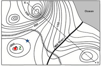
topography
Topographic maps show the land as if viewed from above. Contour lines are used to show the elevation of the land. The contour interval is the distance between consecutive contour lines, it will always be the same for the entire map. Contour lines will never cross or branch, and if they connect making a closed circle, it represents a hilltop. Closed circles with dashes indicate a depression and other key features may be identified using symbols. The closer together the contour lines, the steeper the slope. The farther apart the contour lines, the more gradual the slope.